A 'geopoints' object containing one or more georeferenced data
geopoints.RdGeopoints objects contain data for one or more points defined by their longitude and latitude in decimal degrees. These objects can be read or write to ERSI shape files, or DBF database.
Arguments
- x
A 'geoshapes' object or a data frame with columns 'x' and 'y' for longitudes and latitudes of the points in decimal degrees. For
print()andpoints()methods, it is a 'geopoints' object- File
The path to a .shp (ESRI shape file) or .dbf (DBase) file to import
- format
Either
"shp"or"dbf". If you do not provide this argument, the format is guess from theFileextension- file
The path to an ESRI file where to write data, without extension. Three files are created, with respective extensions .shp, .shx, and .dbf
- arcgis
If
TRUE, the header of the DBF table is made compatible with ArcGIS, that is, dot (.) is replaced by underline (_)- ...
Further arguments passed to the functions (not used yet)
Details
geopoints() converts a 'geoshapes' object or a data frame into a
'geopoints' object.
read.geoshapes() and write.geoshapes() read and write shapes
from or to ESRI shape files or DBase files on disk.
The 'geoshapes' objects have methods to print them, and to
add them to graphs (points at corresponding coordinates).
Value
A 'geopoints' object is returned from geopoints() and
read.geopoints(). The other functions are used for their side-effect
rather than for returning something useful.
Examples
data(mpet)
mpet
#> A 'geopoints' object containing:
#> STATION x y D1 D2 D3 D4 D5 D6 D7 D8 D9
#> 1 SIDI-BEL-ABBES -0.62 35.20 14.5 20.3 18.4 20.0 22.3 20.7 22.5 28.6 39.3
#> 2 OUJDA -1.93 34.78 11.7 15.0 24.0 21.0 23.3 28.0 28.6 32.6 39.0
#> 3 TAZA -4.00 34.22 15.9 14.2 21.9 26.8 30.9 29.5 33.5 37.5 41.5
#> 4 IFRANE -5.17 33.50 18.0 13.4 24.7 25.6 30.1 32.0 37.9 41.0 37.1
#> 5 BOUARFA -1.95 32.57 19.8 20.3 33.6 34.3 39.4 35.3 49.8 48.0 69.0
#> 6 MIDELT -4.73 32.68 10.1 11.6 18.4 19.0 23.9 21.3 23.1 31.8 33.8
#> 7 BENI_MELLAL -6.40 32.37 12.6 15.1 21.8 26.2 29.5 28.5 38.1 38.8 42.1
#> 8 TANGER -5.90 35.72 19.4 16.5 20.6 20.2 20.2 27.3 37.5 41.4 35.5
#> 9 MEKNES -5.53 33.88 16.3 16.2 21.9 22.7 28.6 27.7 44.0 42.6 35.9
#> 10 CASA-ANFA -7.67 33.57 11.0 12.5 16.1 17.6 17.9 18.2 28.9 28.6 35.6
#> 11 SETTAT -7.58 33.03 16.3 17.2 26.4 31.8 33.8 31.6 53.0 45.5 44.1
#> 12 MARRAKECH -8.03 31.62 11.0 12.8 16.6 22.5 26.0 27.4 35.5 38.6 39.5
#> 13 OUARZAZATE -6.90 30.93 19.9 21.0 23.8 24.3 33.0 28.2 38.2 46.2 59.3
#> 14 ESSAOUIRA -9.72 31.52 17.5 18.2 22.3 22.0 19.5 21.7 37.9 28.3 38.4
#> 15 TINDOUF -8.13 27.70 9.0 11.5 14.9 16.6 20.1 19.3 28.4 34.8 47.9
#> 16 BENI-ABBES -2.16 30.13 29.3 25.6 46.7 36.0 30.4 50.3 85.7 53.0 47.8
#> 17 AL_HOCEIMA -3.85 35.18 13.9 16.0 16.7 22.0 24.0 21.3 24.3 31.5 35.5
#> 18 AGADIR_INEZGANE -9.57 30.38 22.9 20.3 32.3 29.3 22.3 41.5 72.9 43.9 43.2
#> D10 D11 D12 D13 D14 D15 D16 D17 D18 D19 D20 D21 D22 D23
#> 1 35.1 44.3 40.7 35.7 30.9 52.9 55.7 46.4 45.5 61.5 50.0 58.6 47.3 53.5
#> 2 36.9 46.0 51.7 48.3 44.7 55.4 62.6 62.7 66.4 77.6 63.9 75.6 62.3 68.2
#> 3 32.6 34.9 39.6 39.7 52.7 56.1 63.9 69.4 71.0 70.6 70.8 74.8 66.5 70.1
#> 4 28.6 35.3 38.5 31.3 56.4 51.0 67.3 76.2 79.3 83.3 73.7 89.3 73.6 77.0
#> 5 61.4 64.8 79.9 83.4 82.1 76.5 84.5 89.3 94.3 111.7 117.9 122.7 90.1 90.4
#> 6 34.8 43.8 48.4 40.1 50.9 57.1 60.9 68.9 69.8 70.8 68.6 69.7 61.2 64.0
#> 7 37.5 42.3 48.2 44.4 52.2 62.7 70.6 76.5 69.5 76.0 75.4 84.2 78.8 79.3
#> 8 34.5 33.7 34.9 39.8 44.6 54.5 64.4 74.2 53.2 61.5 76.5 76.0 78.7 67.2
#> 9 34.7 40.3 39.3 38.5 44.7 55.1 65.1 68.1 60.3 62.5 64.0 69.8 68.5 61.3
#> 10 33.6 41.0 36.0 42.3 39.1 48.8 46.4 48.0 44.3 49.0 48.8 55.3 49.9 45.9
#> 11 34.5 46.1 41.7 47.6 52.9 69.8 73.8 75.8 70.4 72.0 70.6 87.5 78.0 79.2
#> 12 35.2 46.0 49.5 48.4 50.5 68.5 71.2 69.6 72.3 69.8 70.3 78.6 70.5 70.8
#> 13 60.5 68.7 76.5 76.4 80.8 88.5 90.4 80.2 85.2 92.0 100.9 102.0 87.0 84.5
#> 14 32.2 37.6 37.7 38.3 34.9 41.8 34.0 33.2 35.7 32.4 36.1 47.0 38.3 31.0
#> 15 51.4 52.1 64.7 66.9 65.3 67.6 77.9 73.7 77.4 85.5 93.9 96.7 78.1 75.6
#> 16 48.5 46.6 45.9 51.4 42.4 53.2 48.4 47.9 46.7 41.4 43.9 55.0 54.0 45.0
#> 17 38.0 43.9 40.2 34.4 34.5 48.4 48.9 56.3 48.4 61.3 58.9 60.2 52.3 46.3
#> 18 38.4 44.0 44.7 46.4 44.4 56.8 51.6 45.0 44.8 43.0 42.2 53.9 45.1 34.7
#> D24 D25 D26 D27 D28 D29 D30 D31 D32 D33 D34 D35 D36
#> 1 52.6 42.9 40.0 31.9 31.5 26.2 17.9 24.1 16.2 19.0 11.4 12.3 18.8
#> 2 70.6 53.9 48.7 37.1 39.6 27.3 18.9 21.8 16.3 18.7 17.4 22.4 25.1
#> 3 63.4 56.5 52.4 38.4 39.0 25.7 19.4 20.3 15.6 15.7 13.7 17.2 13.9
#> 4 77.8 66.7 56.9 37.7 42.5 23.5 16.3 20.0 16.2 17.3 21.6 19.8 10.1
#> 5 115.6 81.3 82.5 66.5 56.9 45.4 37.0 37.8 27.7 27.4 27.3 23.5 27.5
#> 6 66.6 58.6 54.0 39.6 44.2 30.7 22.0 25.5 21.0 23.4 20.7 20.3 18.0
#> 7 70.7 64.2 57.7 41.8 43.2 28.8 22.6 22.0 17.2 16.4 15.5 16.0 14.6
#> 8 59.0 68.3 42.5 42.7 38.4 31.0 24.5 22.7 18.1 15.4 17.4 14.6 20.6
#> 9 53.0 60.8 46.7 38.5 39.8 26.4 21.3 18.9 18.9 19.0 20.1 21.3 15.0
#> 10 43.2 40.6 34.8 32.0 27.9 23.8 21.2 18.1 14.9 15.5 15.6 15.9 16.4
#> 11 66.3 67.1 51.7 40.3 44.4 30.5 27.7 28.9 25.9 23.5 23.7 29.8 13.7
#> 12 60.2 62.4 51.8 36.7 39.5 27.2 22.7 18.8 16.9 15.5 15.6 10.2 14.5
#> 13 86.6 76.0 75.0 58.3 52.8 47.5 41.4 34.8 28.0 25.7 17.1 18.3 26.4
#> 14 35.4 28.6 31.4 27.9 27.4 25.6 23.8 25.9 20.2 18.3 19.9 23.1 20.4
#> 15 72.1 62.3 65.4 46.3 36.5 30.4 26.5 21.1 17.5 12.1 11.1 11.5 13.0
#> 16 47.4 42.2 47.5 39.7 50.4 34.1 30.6 27.5 25.9 23.5 25.5 29.2 21.1
#> 17 47.2 42.2 33.4 31.2 29.6 25.2 17.1 20.1 14.1 12.3 9.4 9.2 15.4
#> 18 41.3 31.1 36.7 35.9 37.1 29.2 32.7 19.3 24.5 19.9 19.7 27.8 15.5
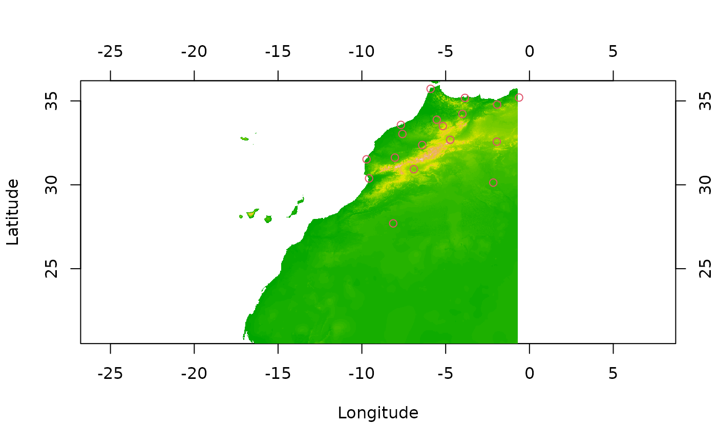
# Plot of Morocco terrain and add the stations location in red
data(morocco)
image(morocco)
points(mpet, col = 2)